|
|
 |
Microwave Remote Sensing of Hurricanes
The AMSU instrument detects earth/atmosphere emitted radiation in the microwave portion of the electromagnetic
spectrum. Microwaves, in comparison to more familiar infrared or visible radiation, are less energetic and have
longer wavelengths (distance between successive wave crests/troughs) on the order of centimeters (10-2 meters)
vs. micrometers (10-6 meters). Based on energy considerations and AMSU-A instrument performance, this dictates
that the sensor be placed in a lower earth-orbit (~810km above the earth's surface vs. ~36,000km for geostationary
satellites) to improve instrument signal-to-noise. The AMSU-A (temperature sounder), a 15 channel
passive radiometer, detects energy emitted by atmospheric molecular oxygen (a major atmospheric constituent)
and is largely unaffected by the presence of clouds--from the emission source, through the atmosphere, to the
sensor which resides on the NOAA-15, NOAA-16 and NOAA-17 polar orbiting satellites.
Contributions to the upwelling terrestrial radiation sensed by the AMSU-A (neglecting the effects of reflection
and scattering which themselves can behave as source/sink terms) are largely comprised of two terms--the earth's surface
and the overlying atmosphere. Individual AMSU-A channels (i.e., frequencies) are carefully chosen based on principles
of radiative transfer theory. Each channel (frequency) is radiatively selective in the sense that it detects microwave
radiation from discrete layers within the earth's atmosphere. Satellite meteorologists typically relate the radiation
sensed in individual AMSU-A channels/frequencies to specific atmospheric layers (characterised by the abundance
of molecular oxygen O2 and temperature) by use of a term called a weighting function:
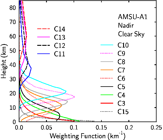
Source: Kidder et al. CSU/CIRA, 1999
Simply put, the weighting function for AMSU-A Channel 7 (54.94 GHz) has a maximum amplitude (i.e., contribution to
upwelling microwave radiation sensed by the AMSU-A instrument) at approximately 250 hPa (~12km above the earth's
surface) whereas Channel 5 (53.6 GHz) has a maximum weighting function at approximately 550 hPa (~5km above
the earth's surface).
As tropical storms develop into hurricanes, they're characterized by upper tropospheric warming (the troposphere being
defined as that portion of the earth's atmosphere extending from the earth's surface to approximately 15km altitude)
as a result of adiabatic warming/compression of air as it subsides (sinks) within the storm center. The following is an
image of Hurricane Bonnie derived from AMSU-A data (contours are degrees C above storm environmental temperature):
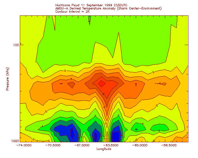
AMSU-A warm anomaly: Hurricane Floyd
AMSU observations of the hurricane in the South Atlantic.
Return to Lesson 12
Return to Satellite Meteorology Main Page
CIMSS AMSU page
|

