|
|
 |
Lesson 8: Background
GOES Sounder characteristics
The GOES-8 sounder (see Table 1
for instrument features) has 18 thermal infrared bands plus a low-resolution visible
band. The field of view is 8 km and is sampled every 10 km; 13 bit data is transmitted.
The GOES-8 sounder spectral selection was mostly patterned after the
High-resolution Infrared Radiation Sounder (HIRS) carried on the NOAA polar-orbiting
satellite. It has six bands in the 15 um (longwave) band, a split-window pair, three
midtropospheric water-sensitive bands and an ozone band (midwave), five 4 um (shortwave)
bands, and a visible band.
The spectral bands, some at wavelengths never obtained before in geosynchronous orbit,
are sensitive to temperature, moisture, and ozone.
Table 2 summarizes the
spectral band performance characteristics for the GOES-8 sounder, measured in-flight.
Table 3 shows the in-flight determination of noise performance
of the GOES-8 sounder and compares it with the GOES-7 VAS and NOAA-12 HIRS performance.
The GOES-8 sounder's design goal,
like the imager's, is to provide brightness temperatures with 1.0K absolute accuracy
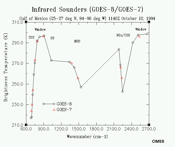
and 0.3K relative precision. The quality of the absolute calibration is evident when
collocated GOES-8 sounder and VAS radiances are
compared; the brightness temperatures for the different spectral bands on each
instrument are charted as a function of wavenumber. The GOES-8 sounder and VAS radiances
agree within 2.0K; the GOES-8 sounder's additional spectral bands provide more
atmospheric detail.
The full-time
availability of the GOES-8 sounder enables operational sounding products for the first
time; this has the potential for contributing significantly to mesoscale forecasting
over the conterminous United States, monitoring thermal winds over oceans, and
supplementing the Automated Surface Observing System (ASOS) with upper-level
cloud information. The GOES-8 sounder will also allow for the development of a
number of advanced products.
Sounder imagery
The following imagery demonstrates the sounder's capabilities for a representative
sampling of its long, mid, and short-wave spectral bands:
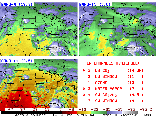
- Long-, mid-, and short-wave imagery
from the GOES-8 sounder at 1414 UTC on 6 June 1994. Carbon dioxide
sensitive longwave band 4 (13.7 micrometer) sees the middle to upper level
tropospheric temperature patterns. Smooth transitions showing the cooling
further north are evident in clear regions; this is proof of the good signal to
noise accomplished in this difficult portion of the spectrum. Water vapor
sensitive midwave band 11 (7.0 micrometer) sees the middle tropospheric
moisture fields. Dry pockets are obvious in Colorado/New Mexico, Texas,
Louisiana/Mississippi, and Michigan. Carbon dioxide sensitive shortwave band
14 (4.5 micrometer) sees the middle to lower level tropospheric temperature
field; contrast with band 4 indicates the warming in the lower atmosphere. The
distribution of all GOES-8 sounder bands by spectral region and sensitivity to
primary atmospheric constituents is given in the lower right panel.
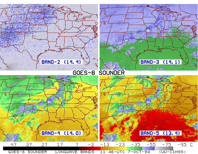
- Images from four of the longwave carbon dioxide
bands
of the GOES-8 sounder are shown for 1146 UTC on 7 October
1994 over the central United States. From the upper left panel (band 2 at
14.4 micrometers) across to the right (band 3 at 14.1), and then from the lower
left (band 4 at 14.0) across to the right (band 5 at 13.4), the imagery depicts
a process of progressively sensing lower and lower into the atmosphere, as the
wavelengths of the sensed radiation decrease. See how the equivalent blackbody
(or "radiative") temperatures increase from band 2 through band 5 in a
generally cloud free region, such as the Gulf of Mexico, from gray to green to
yellow to red, indicative of the general lapse of temperature with height in
the troposphere. Note how the clouds along the front, extending from the
western Great Lakes to the Texas Panhandle, are seen in the latter three bands,
but not in band 2 (even including the convection in southwest Missouri and the
Texas Panhandle). Only the highest cloud tops (along the west coast of Mexico
and in the central Gulf of Mexico) are sensed with band 2. Also, note how for
bands 3 through 5, the general temperature pattern shows cooler air to the
northwest with warmer air to the southeast; however, for band 2, the gradient
is reversed with warmer air to the northwest. Radiances in band 2 are actually
sensing the lower stratosphere (just above the tropopause) where the
north-south temperature fields are reversed from those below.
- Midwave water vapor imagery
from the GOES-8 sounder at 1146 UTC on 7 October 1994. Progressively less water
vapor transparent bands (8, 10, 11, and 12) become more sensitive to middle and
upper tropospheric moisture. Dry and moist tongues become obvious in the band
12 (6.7 micrometer) image as one progresses upward through the bands starting
with the band 8 (10.8 micrometer) window image. It is interesting to note that
band 11 (7.0 micrometer) has a factor of twelve improvement (in higher
horizontal resolution and better signal) over the similar GOES-7 water vapor
band.
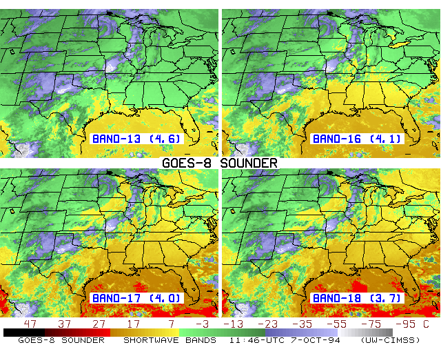
- Shortwave imagery
from the GOES-8 sounder at 1146 UTC on 7 October 1994.
Progressively more carbon dioxide transparent
bands (13, 16, 17, and 18) see deeper into the atmosphere and sense more
radiation from the earth surface. Reflected solar radiation in band 18 (3.7
micrometer) indicates cloud top and earth surface properties. Note how Lakes
Erie and Ontario become more distinctive with decreasing wavelenth.
The retrieval overview.
More from the CIMSS page on GOES Sounder
Return to Satellite Meteorology Main Page
AOS Main Page
Current Madison Weather
CIMSS GOES Gallery
|

