|
|
 |
Lesson 2: Assessment
There are two parts to this assignment:
PART I
Use McIDAS access an infrared image. Identify three weather features, describe and explain the appearance of these images.
PART II
The weighting function provides in formation on what regions of the atmosphere are affection the satellite measurements. It is determined by the absorption properties of the a gas, the gas concentration, the vertical distribution of the gas and temperature profile. In this simplified exercise we neglect the temperature dependence and investigate how changes in the line shape, the gas concentration, and the vertical distribution of the gas impact the weighting function.
- Using the radiative transfer equation for the infrared (and clear sky)
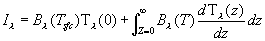
and the applet describe why the weighting function changes as the observation wavelength moves from the line center to the line's wing.
- The water vapor image on the GOES makes observations around 6.7 micron, a relatively strong absorption band of water vapor. Do you think the 6.7 micron channel ever sees the surface?
- Given a uniform atmoshpere in the horizontal direction (there are vertical variations in temperature and humidity),
how would the brightness temperature measured at nadir (straight down from a satellite) compare to a measurement at
an angle of 40 degrees off-nadir (e.g. same, greater than or less then)? Explain your reasoning.
Return to Lesson2
Return to Satellite Meteorology Main Page
|

