|
|
 |
LESSON 3: STATION MODEL PRACTICE
Television weather reports represent weather conditions
with smiling suns, rainy clouds and flashing bolts of lightning. In studying
the weather we need to know where it is raining and where it is sunny,
the wind speed and direction, humidity, visibility, pressure and temperature.
To understand the weather we need to know how these meteorological variables
are changing and how they relate to one another. To understand these relationships
it is best to represent weather variables in a simple graph. Smiling suns
do not contain enough information about the weather. On the other hand
too many numbers drawn on a single map presents a confusing picture. Weather
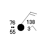
conditions observed at a city or town are best represented on a map using
the station model.
For practice using realtime data
Press Here
Next Page | Practice
Exercises | Learn
Contouring
Return to Lesson 3 Page.
Return to Weather For Pilots Main Page
Local
Madison Weather
|