|
 |
LESSON 3
CONTOUR ANALYSISMaps depicting weather and ocean conditions are drawn based on simultaneous observations made at many places throughout the world. Accurate portrayal of these observations is the key to a correct interpretation of the data. Meteorologists and oceanographers use a technique called contour analysis to visually explain the information the data is providing. Contouring data represents an elementary step in data analysis. Ability to correctly and confidently analyze data is critical to interpreting conditions. For example, contouring is vital in:
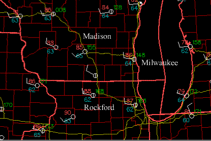
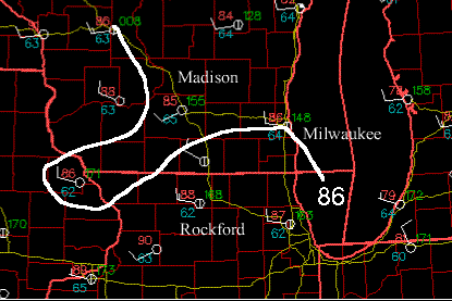
An isopleth is a line of equal value (a Greek word iso - equal; pleth - value). Contouring is the process of drawing isopleths. A weather map contains isopleths of different weather parameters (Table of common isopleths). For example, maps of forecasted high temperatures have contours of constant temperature, or isotherms (iso-equal; therm-temperature). On these maps, anywhere along the 70 degree isotherm the forecasted high temperature is 70 degrees. Contouring data can be difficult because observations are not made everywhere. Gaps in the observations exist and we must interpolate between the existing weather observations. For example, the weather map below depicts weather conditions on July 15, 1997 at 1900Z in the southern Wisconsin and the surrounding states. The red numbers are the observed temperatures, in degrees Fahrenheit. The city of Madison, WI has a temperature of 85F while Rockford, IL has a temperature of 88F. If you where to drive from Madison to Rockford on I90 (the yellow line) with a thermometer, along the way you would measure temperatures of 86F and 87 F. If we were to draw an isotherm of 86F, this isotherm would have to pass between Madison and Rockford, and through the city of Milwaukee, WI where the observed temperature is 86F. The adjacent map analyzes the 86F isotherm as a thick white line. Ocean data is even more sparse than weather data!
Contoured maps are common. You see them in the weather section of your
newspaper, a map of the Earth often includes two contour analyzes -- one
of latitude and the other longitude, and hiking maps depict lines of constant
elevation.
Follow these general rules of contouring as you analyze these maps:
Lesson 1: Introduction to contouringIn this first exercise, you will use the mouse to practice contouring. You might start analyzing a contour by drawing tic marks on the map to mark where the isopleth should be, then connect the dots. Don't worry about trying to get the lines perfectly smooth. The purpose is for you to gain an understanding of how contouring is accomplished. Notice that contour lines cannot cross, but they can form closed loops.Lesson 2: Learning the BasicsIn this next exercise, you will again use the mouse to contour a map. You will be presented with a series of plotted data points that will determine the contoured field. Contour the field before looking at the answer! As you go through this first exercise notice how the contour field changes as you add observations to the map. The more observations you have, the better the field is defined.Lesson 3: Intermediate LevelTo become adapt at contouring requires practice!When you are done with this map, notice the spacing of the contours. The spacing of the isopleths indicates how rapidly conditions are changing in the horizontal direction. The gradient of a variable describes how much the variable changes over a given distance. The more densely packed the isopleths, the larger the gradient.Lesson 4: Working with Real DataIn this exercise you will be presented with observations of surface dew point temperatures on 1200 UTC, July 18, 1996. Unlike the previous exercises, all the observations are plotted on the map at once. But don't let this bother you. Before drawing your first contour invest some time in preparation.
In real analysis lab, you would be using a pencil instead of a computer mouse so that you can erase the inevitable mistakes.
In this exercise you will be presented with a weather map
that includes observations of temperature, dew point temperature,
and wind speed and direction made at 1400UTC on July 18, 1996. On
this day a tornado touched in in Oakfield, WI. The observations are
all plotted on the map at once, so don't get temperature confused with
the dew point! Do you notice a relationship between temperature and
dew point?
|
| Isobar | Pressure |
| Isotherm | Temperature |
| Isotach | Wind Speed |
| Isogon | Wind Direction |
| Isoshear | Wind Shear |
| Isodrosotherm | Dew point |
| Isohyet | Precipitation Accumulation |
| Isohaline | Salinity |
| Isopycnic | Density |
| Isohume | Humidity |
| Isoneph | Cloudiness |
| Isohel | Sunshine |
Return to Lesson 3 Page.
Return to Weather For Pilots Main Page