Determining Atmospheric Stability
The severity of a thunderstorm is largely dependent on the stability of the atmosphere. We can determine if an atmosphere is stable or unstable by plotting temperature as a function of altitude and comparing it to the dry and moist adiabatic lapse rates. This method of determining the stability of the atmosphere is called the parcel method.
Another approach to determining favorable conditions for thunderstorm development is to compute a stability index.
Stability indices are a measure of the atmospheric static stability. They show the differences between the temperature and dew point of the air near the surface and those in the middle layers of the atmosphere. There are different stability indices; each seeks to identify warm moist air underlying cooler, drier air. The indices are based on the stability concepts and the fact that moist air is less dense than dry air.
The simplest stability indices compare the temperature of a parcel of air low in the atmosphere with air in the middle troposphere. Stability indices are useful to forecasters in recognizing regions threatened by severe weather. A common stability index is the Lifted Index. The lifted index is the temperature difference found by subtracting the temperature of a parcel of air lifted from the surface to 500 millibars from the exiting temperature at 500 mb. If the observed 500 mb temperature is colder than the lifted air parcel then the lifted index is negative and the atmosphere is unstable to vertical air motions, like those found in cumulus and cumulonimbus clouds. The lifted index numbers are related to thunderstorm severity. A lifted index of between 0 and -2 indicates that the chances are small for thunderstorms. Values between -3 and -5 indicate a moderate chance of a thunderstorms. Values less than or equal to -6 indicates conditions are very favorable for development of thunderstorms with a high likelihood that if they occur, they would be severe with high winds and hail. The Lifted Index does not tell the probability of occurrence of a thunderstorm. The Lifted Index evaluates the severity of the thunderstorm if one where to occur.
The K-index is useful in determining the probability of occurrence of a thunderstorm. The K index is computed as:
K Index = (T850- T500)+ TD850 + (TD700- T700)
Where T850, T700 and T500 are the 850-mb 700-mb and 500-mb temperature, respective and TD850 and TD700 are the dew point temperatures at 850 mb and 700 mb. All temperatures are in degrees Celsius. The first term on the left hand side is a measure of the lapse rate between the 850 and 500 mb layer. The air is less stable when this difference is a large positive number. The second term represents the amount of moisture in the lower layers of the atmosphere. If the dew point at 850 mb is high, then there is an increase in the instability of the atmosphere due to the release of latent heat when the air is lifted to saturation. The last term represents the dryness of the 700 mb layer. When the difference between the dew point temperature and temperature at 700 mb is large, the air at that level is dry. Dry air over warm moist air is unstable, conditions favorable for thunderstorm development.
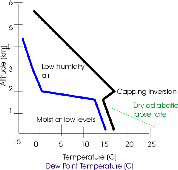
A typical temperature and dew point temperature profile of an atmosphere that is very unstable. Notice the warm moist air near the surface and the cooler drier air in the middle troposphere. The vertical wind structure from Earth's surface to near 300 mb, is also important in determining conditions that can lead to severe weather.
Return to Lesson 9 Page.
Return to Weather For Pilots Main Page
Local Madison Weather
