|
 |
LESSON 4
Geostrophic and Gradient Winds - Observations of Upper Air Winds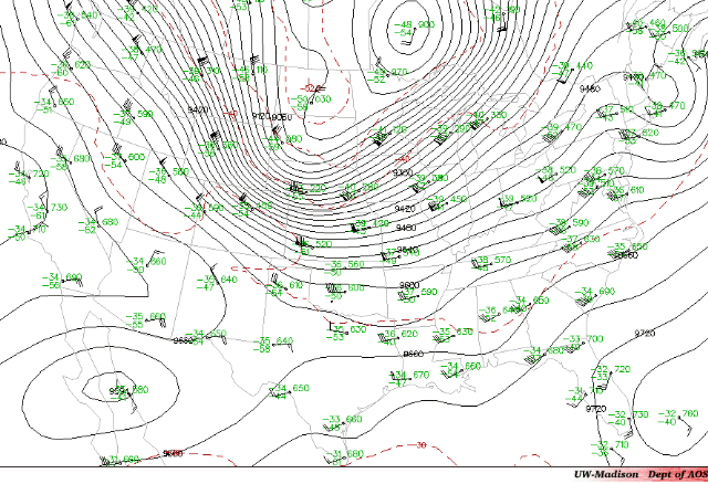 The figure above is a map of the 300 mb pressure surface. Let's make three observations.
To explain the first two observations consider the following simplified situation
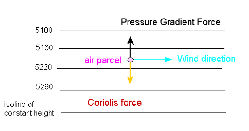
The isolines of constant height are parallel to one another with lower heights at the top of the page. By our observations, the wind is blowing parallel to these lines as drawn. The wind is moving in a straight line parallel to these isolines. Also shown in the figure are the forces acting on a parcel of moving air. There are only two forces acting: the pressure gradient force and the Coriolis force. The pressure gradient force acts towards low pressure perpendicular to the lines of constant height while the Coriolis force acts to the right and perpendicular to the wind direction. The two forces are acting in opposite directions and are of equal magnitude. A wind that results from a balance between the pressure gradient and Coriolis forces is called a geostrophic wind. When forces are in balance, there is no net force. How does the air move if the two forces are balanced? To answer this question imagine an air parcel released from rest as in the following figure
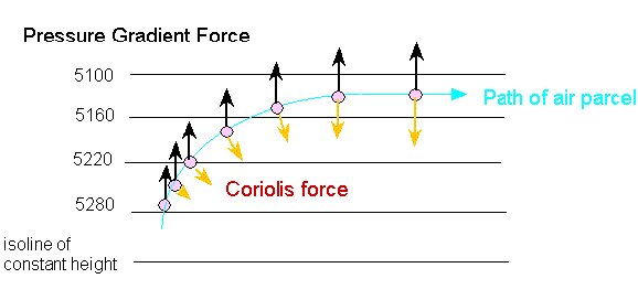
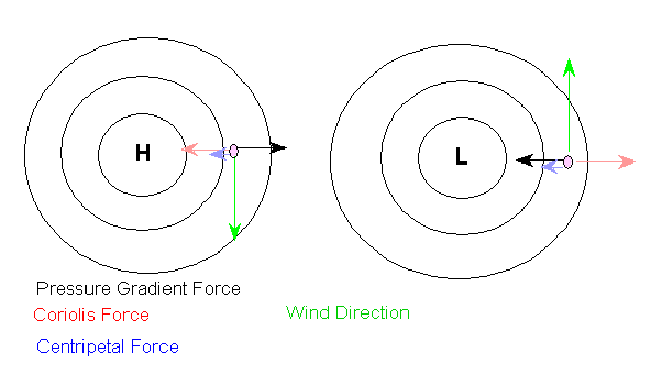
Initially, since the parcel is at rest, the Coriolis force is zero. The pressure gradient results in a force that accelerates the parcel of air towards lower pressures. Initially the parcel moves in the direction of the pressure gradient force perpendicular to the isoheights. Once the parcel begins to move, the Coriolis force acts to deflect the parcel's path to the right, assuming we are in the Northern Hemisphere. As the wind speed increases because of the pressure gradient force, the Coriolis force strengthens and moves the parcel causing the parcel to travel in a curved path. Eventually the Coriolis force and the pressure gradient force are equal and acting in opposite directions. Although the net force acting on the parcel of air is zero, the parcel continues to move because of Newton's First Law of Motion. The parcel is in motion and tends to remain in motion. Lower heights are to the left when you face downwind. In the upper atmosphere winds blow parallel to the isoheights. The winds change direction to remain parallel to the constant-height lines. According to Newton's first law of motion, forces are acting to change the direction of the wind. To explain this consider a simplified situation: In this case the lines of constant-height are curved and the pressure gradient and Coriolis force are not in balance. The net force is the centripetal force which results in changing the wind direction. The wind is now a result of three forces involved, the pressure gradient, Coriolis and centripetal forces. This type of balance results in a gradient wind. When the Coriolis force is greater than the pressure gradient force, the wind curves clockwise (in the Northern Hemisphere). The centripetal force points towards regions of higher pressure. When the pressure gradient force exceeds the Coriolis force, the air curves counterclockwise in the Northern Hemisphere (clockwise in the Southern Hemisphere). In this case the centripetal force points towards regions of lower pressure. Thus, in the Northern Hemisphere, winds flow clockwise around regions of high pressure and counterclockwise in regions of low pressure, in agreement with our observations. Return to Lesson 4 Page. Return to Weather For Pilots Main Page
|