
|
 |
Upper Air
So far this semester we have focused our attention on surface weather maps. But there is more to the weather patterns then what is available from surface information. Weather of the upper levels of the atmosphere is quite important to how the weather behaves at the surface. Balloons are launched from sites all over the United States, twice a day, to give us detailed information about the winds, temperature, pressure, and humidity in the atmosphere above. This information is then plotted on upper level maps, or upper air charts. We will begin by discussing how these upper air charts are drawn. Then we will look at how forces drive the wind, and we will see that different forces affect the surface winds and the upper level winds. The punch line is that we will look at how flow aloft can affect weather systems near the surface. Upper level maps
One feature which is different on upper level maps is that meteorologists are no longer looking at the surface where the pressure varies. Instead, they look at a constant pressure surface, which will appear warped if viewed from the side: 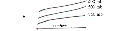
Thus, whenever you look at an upper level map, you are always looking at the same pressure on one map! In this case, instead of pressure given on a station model, height above the surface is given, in the same location on the model where the pressure was. For example a 500 mb model would look like: 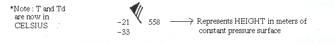
There are 5 basic height maps meteorologists use, and for each map, the heights are truncated to keep clutter off the map. You decode those heights as follows:
Standard levels What you do to translate height Examples Surface plot = Put a 10 or 9 in front 850 mb = Put a 1 in front..........545 is 1545 700 mb = Put a 3 or 2 in front, whichever brings you closer to 3000 meters..........045 is 3045 AND 968 is 2968 500 mb = Put a zero on the end..........540 is 5400 300 mb = Put a zero on the end..........945 is 9450 250 mb, 200 mb = For both these, the first digit is a 1 or 0, whichever brings you closer to 10,000. Also put a 0 on the end..........220 is 12200 This height is also sometimes referred to as the geopotential height. (For the purposes of this discussion, we will look focus on the 500 mb and 300 mb chart but you should be aware of the others.) Since typically lower heights represent lower pressure, and higher heights represent higher pressure, contouring heights can help us see the flow, like isobars do at the surface. Contours are now no longer of constant pressure, but of constant height. While the flow behaves similarly in the upper levels, there are some differences in how the wind flows at the upper levels as compared to the surface. Winds Winds behave the way they do due to forces that act on them. If you had a baseball, its not going to move itself, you must exert a force on it to get it to move. The air in the atmosphere acts the same way. Different forces are useful in determining the winds at different levels, so we will start with what we know, the surface winds. Surface winds have three main forces acting on them. We know that the pressure gradient force (PG) influences the wind to move from high to low pressure. However, since we are on a spinning planet, the Coreolis force (Co) acts to pull the air parcel to the right. Lastly, at the surface we have friction (Fr), which slows down the movement of the parcel, therefore decreasing the coreolis force. The net result is that at the surface, wind crosses the isobars slightly, to move in toward low pressure and out away from high pressure. 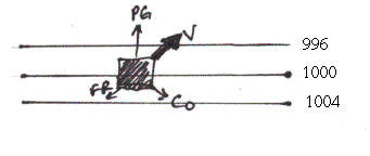
In the upper levels, we have similar forces; Pressure gradient and Coriolis. However, since we are far away from the surface, we can neglect friction, leaving only PG and Co in balance. When this flow is straight, this is called geostrophic balance or geostrophic flow: 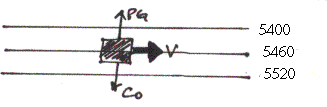
Thus in the upper levels, the winds tend to flow along the lines of constant height. Geostrophic balance in and of itself does not generate changes in weather patterns; it is when the geostrophic flow is altered that changes occur. Influences on surface weather Imagine a geostrophic flow on an upper level chart. If we add curvature to the flow, the flow is no longer purely geostrophic, and can thus be an influence on surface weather - we sometimes call this flow gradient flow, because curvature is included. We still have the balance between PG and Co, but now due to the curvature of the flow we must consider centripetal force. (Ce) (This is the same force used in amusement parks that pins you to the wall on those rides where they drop the bottom out.) Since this alters the speed of the wind in the bases of the troughs (slowing) and tops of the ridges (increasing), this leads to convergence aloft between the ridge and the trough, and divergence aloft from the trough to the ridge. 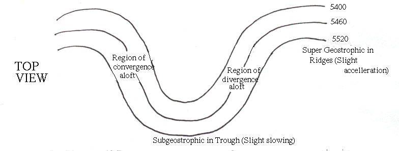
Recall how we said divergence and convergence affect flow at the surface, now just imagine that same effect in the upper levels. You can see from the following diagram that convergence aloft can lead to sinking air at the surface, and divergence aloft can lead to rising air at the surface: 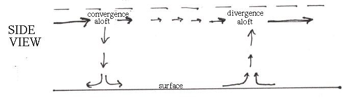
This may not only enhance an existing Low at the surface in the region of divergence aloft, but may actually cause one to occur if the divergence aloft is strong enough. Most of the time surface storms grow in strength from the trough to the ridge, in the area of divergence aloft. The 500 mb chart is a good chart on which to look for areas of convergence and divergence. Background MaterialMore information from the ww2010.Return to Upper Air Lesson. Return to Lab 101 Main Page
|