How it works and how its used in meteorology
Similar to last week, below you will find informational notes
for radar. Imbedded in these notes you will find figures which are very
helpful in understanding what radar is, how it works, and the different
types used in meteorology. Included in the exercise are some
examples, to get you used to the different kinds of radar imagery.
Starred (*) figures are taken from
the WW2010 Project at the Department of Atmospheric Science, University of
Illinois-Urbana/Champaign. Figures noted with a (+) appear courtesy of
Pete Chaston, National Weather Service, Ret.
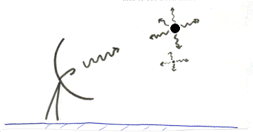
RADAR
- Ra
dio Detection and Ranging
- Sends out a pulse, listens for return signal
- Wavelength of 5-10 cm
- Beam is typically 1°
inclined and 1.5°
wide, and rotates to see a full circle or sweep
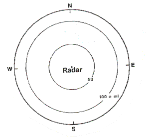
- Typically sweeps out 200 nautical miles
CONVENTIONAL radar
- The more signal which bounces back, the more intense the echo or
reflectivity
= more intense precipitation
- Echoes are displayed on a radar screen
- Radar screen is color enhanced to show intensity of precip
- Can not only sweep in a circle, but can also be moved up and down in
clouds, look at different levels, individual storms
- These images are usually labeled BASE REFLECTIVITY
Conventional radar Good for:
- Seeing bands/location of precip and their intensity
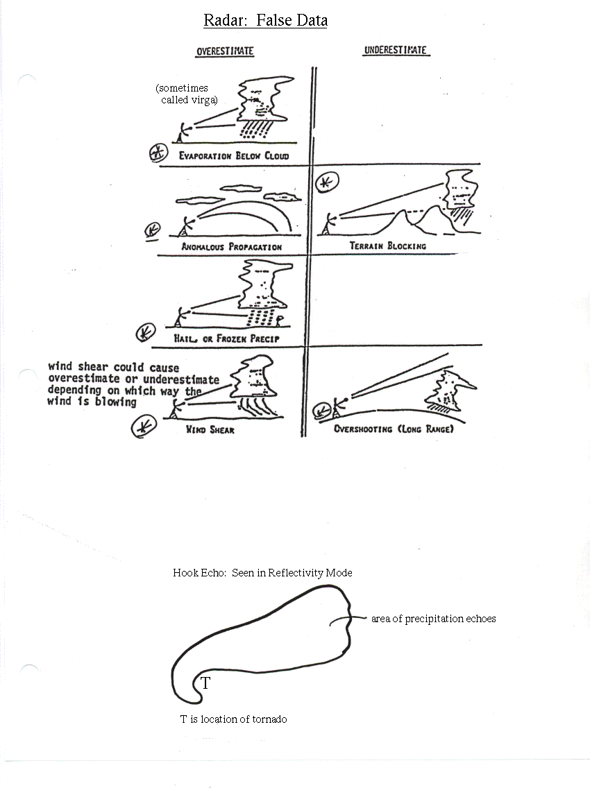
- Hook echoes
- Bow echoes
Some problems:
- Ground clutter, bouncing off things other than preciptation
- Overestimation/Underestimation of precip (See Handouts)
- Cannot tell type of precipitation by radar alone!! (Have to use
temperatures, actual observations, etc.
DOPPLER Radar
- Operates on principle of Doppler shift
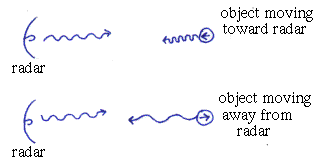
- Measures the actual speed/direction of the wind NOT the actual amount of signal reflected. Image will be labeled with some kind of VELOCITY
term, like STORM RELATIVE VELOCITY
- Many so-called doppler radars can operate in either a conventional
or doppler mode. The weather community shows reflectivities, or conventional
data, to the general public. I.E...
- As a civilian, you will almost NEVER see the velocity or Doppler
wind field image!
- Just because they call it a doppler
doesnt mean its in doppler mode...
Doppler Good for:
- Showing tornado vortex signatures, mesocyclones (also see below)
- Wind shear
- Anything for which you need information about the wind field
NEXRAD- Next Generation Radar - A specific
kind of Doppler
- A software used with the WSR-88D series doppler radar (Weather
Service Radar, 1988 Doppler)
- Uses data obtained by both Doppler and Conventional radar to work out algorithms for detecting mesocyclones, hail, tornadoes,
etc.
Good for:
- Short term forecasting and warnings during severe weather events
- Finding mesocyclones, tornado vortex signatures, microbursts, hail and
hook echoes. Might catch these things before the human eye does!
- Can monitor storm motion
LIDAR- Light detection and ranging
- Experimental, but small wavelength makes it useful
- More resolution--Can actually see clear air convection using very
tiny particles such as aerosols
Lots and lots of websites about the many uses of satellite and radar!
This is our department homepage, go down to current weather observation maps, and look for satellite images and loops. You can click here, and you can also see various radar sites by clicking on any choice below NEXRAD Radar from on t
he same page.
#O
This is a great site with a big list of various storms, and lots of images. I suggest you just go here and browse around; Notice at the bottom you can see the very first picture from space, and a neat movie of the Mt. St Helens eruption. Be sure to look at what kind of image you are viewing (infrared or visible), it will help you get used to seeing the different kinds of images.
This site has Doppler radar images and Satellite images for national and regional. Its got a lot of stuff on it, radar is listed first and then you can scroll down to see satellite images. Once again, just look around for interesting stuff!
This is a good site for comparing conventional versus Doppler radar. Start here, and for other examples just go to the bottom of the page and go to the next city.
Up to the moment tracking of NOAA satellites--Updates as you watch!! Cool!
Same as above only tells you where space projects are in real time, MIR, shuttle, Hubble, etc.
GPS (Global Positioning Satellite) and its usage in tracking worldwide continental drift and earthquakes in California
Some good examples of Landsat imagery on various levels (country, state, city, etc.)
A great overview of POES vs GOES
The UARS (Upper Atmosphere Research Satellite) homepage
Want a device that could save your life while sailing? See how NOAA satellites can find you anywhere on the globe
The COBE (Cosmic Background Explorer) home page
For those of you who like pretty pictures, theres a neat page with images sent back from the Hubble Space Telescope
Return to radar lesson.
Return to Lab 101 Main Page
Local Madison Weather

