Ahrens defines a front as the boundary between unlike air masses,
and as the transition zone between air masses of different densities.
While sufficient, we will use a more complete definition for the
purposes of this course which is:
a front is the edge of a transition zone between unlike air masses,
because as we have seen a true distinct boundary can be difficult
to discern. This exercise is designed to show how data such as
temperature, pressure and wind can all be used to find fronts. It is
truly a matter of finding the best place for the front based
on these variables, because nature rarely gives a perfect textbook
case where all of the variables are obviously different.
So the main purpose of this exercise is to learn the types of
fronts and ways in which to identify them on a map.
There are 5 basic kinds of fronts:
Cold front--
The leading edge of a transition zone where a cold air mass is replacing a warmer air mass
Warm front--
The leading edge of a transition zone where a warm air mass is
replacing a colder air mass
Stationary front--
A zone where a warm air mass and cold air mass meet, but the masses
are not currently moving
Occluded front--2 types:
Cold occlusion-
Very cold air moving into cold air
Warm occlusion-
Cool air moving into cold air
Dry line--(Special case)
A boundary between air masses with similar temperature characteristics,
but different humidity characteristics
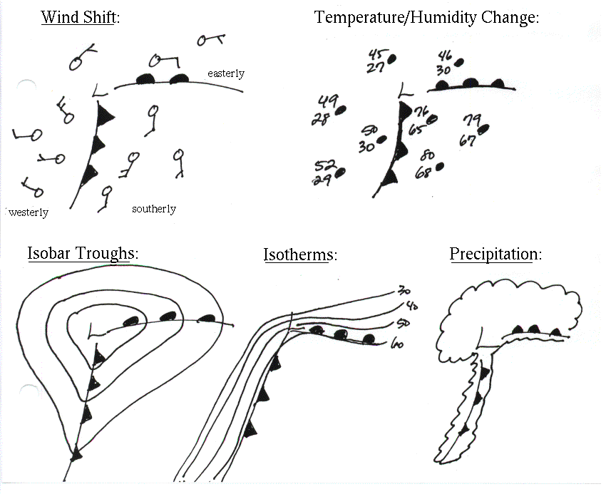
Finding fronts on a Map-(Figure 8.12 on page 201 is an excellent reference for this)
Look for some of the following things on a surface map in order to identify fronts (In order of the TAs preference!)
-Wind shift
-Rapid temperature change over a small distance
-Humidity change
-Troughs in Isobars
-Cloud and precipitation patterns
-Leading warm isotherm
-Pressure tendency
*An important note! In general, warm fronts are more
difficult to discern than cold fronts. Their transition zones
are typically much larger and their affects much more widespread.