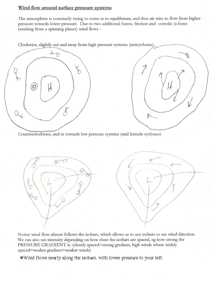
Recall from last time that a
line of equal pressure is defined to be an isobar. This week you
will be
contouring isobars on a station model map, which will enable you to
see
more clearly the general wind direction at the surface. This, in turn,
can show you what kind of air (cold, warm, dry, moist) is coming toward
you. You can also see the intensity of the pressure systems
themselves, wh
ich can tell us how well developed a storm system may be. There are
some basic important things to remember about drawing isolines, and I
refer you to the rules and example of isobars in exercise 2.
To make things a little easier, following the steps below makes
pressure easier to contour.
1) Identify the pressure on each station model. Remember to:
A) insert the decimal to give the number a tenths place;
B) add the 9 if the first 2 numbers are greater than 55, or a 10 if
the first two numbers are less than 55.
example: 184 = 1018.4 mb
997 = 999.7 mb
2) Identify your stations with the highest and lowest pressure. Mark
the highest with a blue H and the lowest with a red L.
3) Center your map on 1000 mb, and use intervals of 4 milibars.
This does not necessarily mean that you have a 1000 mb line, but it
does assure that everyone uses the same numbers for the lines;
like 992, 996, 1000, 1004, 1008, 1012. YOU SHOULD NOT SEE AN INTERVAL
ON A PRESSURE MAP THAT ISNT A MULTIPLE OF 4 AND NOT BASED ON 1000, FOR
EXAMPLE 1005. Sometimes it is helpful to jot these numbers in your
margin, as you will have to add and subtract multiples of 4 from 1000!
4) Remember to interpolate between stations as exactly as possible;
a line of 1000 mb going between a station reporting 997 mb and a station
reporting 1001 mb will go a bit closer to the station reporting the 1001
mb value.
5) When you are contouring, use the circle of the station as the
point you are contouring around. Dont use the pressure number itself
for this point, as it could be half a state away from the actual reporting
station!