SATELLITE IMAGERY
Observations from instruments flown on satellites are used extensively in weather analysis.
The radiometers flown on satellites are not cameras. Moving mirrors
make the radiometer view different regions of the earth. The instrument
begins by looking off in one direction and then scans across a
scene making observations as it proceeds. In this manner the radiometer
scans a scene line-by-line. Data is recorded in a two-dimensional
format (line and element) which, when displayed on a computer
monitor or television screen, makes up an image. The smallest
part of this image is the pixel -- which stands for "picture
element." The radiation coming from each pixel is presented
in an image format in terms of a gray scale. An image consists
of 256 gray shades, ranging from 0 for pure black to 255 for pure
white.
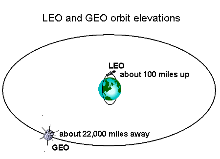
Weather
satellites fly around the Earth in two basic orbits: a Geostationary Earth Orbit (abbreviated as GEO) and a Low Earth Orbit (also called LEO).
Flown on board satellites are instruments that measure electromagnetic energy that is either reflected or emitted by our planet. These instruments are called radiometers. Two common types of radiometers are used in satellite meteorology. One type measures the amount of visible light from the sun reflected back to space by the Earth's surface or by clouds. The second measures the amount of radiation emitted by these entities.
Interpreting these satellite images is important to understanding weather conditions and how they are changing.
Interpreting Satellite Visible Images.
Satellite visible image depict reflected sunlight with visible wavelengths (wavelength range is typically .5 to .9 microns)
Satellite visible images are useful for:
Seeing basic cloud patterns and storm systems;
Monitoring snow cover;
Shows nice shadows of taller clouds, has a 3-D look to it.
Disadvantages:
Only useful during the daylight hours;
BR>Difficult to distinguish low clouds from high clouds since all clouds have a similar albedo (reflect a similar amount of light);
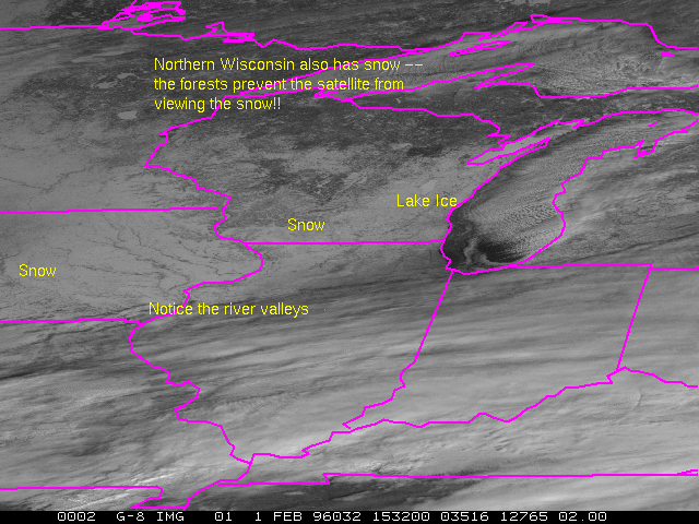
Hard to distinguish snow from clouds in winter.
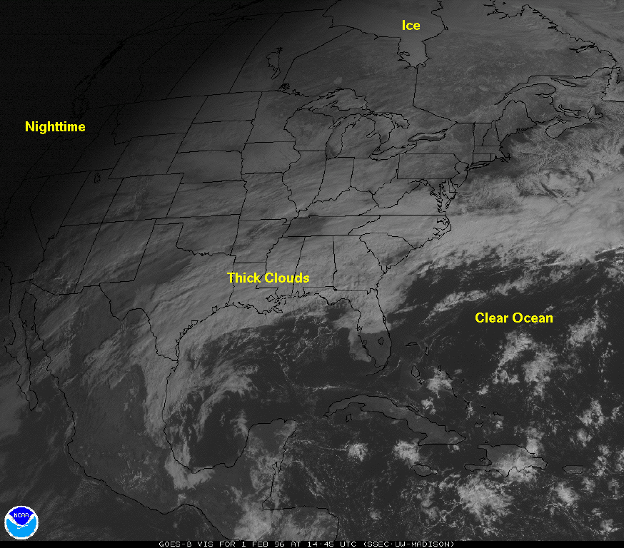
Dark areas in a visible image represent geographic regions were
small amounts of visible light from the sun are reflected back
to space. Whiter regions are objects that are highly reflective.
The oceans are usually dark while snow and thick clouds are bright.
Don't be fooled by visible imagery.
Latest GOES-8 visible image.
Latest GOES-9 visible image.
Interpreting Satellite Infrared (IR) Images.
Records emitted infrared energy, typically with wavelengths between 10.6 and 12.5 microns. Since the detectors measure emitted radiant energy, the instruments can be during the day or night. Typically colder objects, such as high thick clouds show up white. The whiter the object the colder the cloud, if it is a thick cloud. Thin cirrus can appear gray as some energy emitted by the warm underlying ground or water is transmitted throught the cloud and reaches the satellite.
Sometimes IR images are colorized to draw attention to cold clouds which typically identify precipitation regions.
IR images are useful for:
Distinguishing higher clouds from lower ones
Observing storms at night
Distinguishing clouds from snow cover.
Disadvantages:
Sometimes hard to distinguish between a thick cirrus and thunderstorms,
Makes clouds appear blurred with less defined edges than visible images.
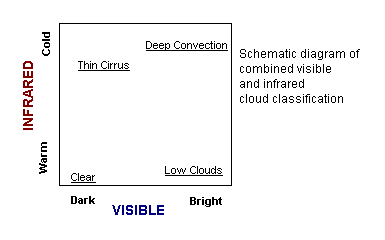
Interpreting Satellite Visible and IR Images.
The good way to interpret satellite images to view visible and
infrared imagery together. This helps to overcome the disadvantages of each image. For example, the visible image can be used to detect snowfall. The IR image can distinguish low thick stratus from high thick cirrus, both of which appear while in the visible image, but only the cirrus appears white in the IR image. The combination can also help to identify thin cirrus, which appears grayis in the visible image and white in the IR. Thick altostratus will appear white in the visible and gray in the IR image.
The following Java Applet allows you to morph between a satellite visible and infrared image so you can investigate the advantages of using the two observations together.
