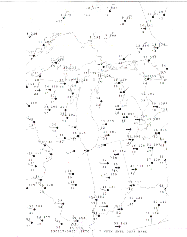
Part 1 - Decode the following Surface Station Models
Use correct units!!
|
Station A |
Station B
|
|
N__________ |
N_________ |
|
dd_________ |
dd________ |
|
ff__________ |
ff_________ |
|
VV_________ |
VV________ |
|
PPP________ |
ww________ |
|
TT_________ |
PPP_______ |
|
TdTd_______ |
TT________ |
|
TdTd______ |
|
|
+pp______ |
|
|
a__________ |
|
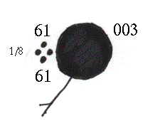
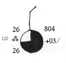
How would you briefly describe what the weather is like at each of these places?
Station A:
Station B:
Part 2: The Map
Given the attached weather map, locate the following:
1. The regions experiencing cloud cover. This can be pretty general, like states, provinces, etc. (Write your answer here, not on the map.)
Questions about the map--Concept questions:
1. What do you notice about the relationship between weather/cloud cover and the lowest pressure?
2. How are the winds circulating around the low? (clockwise=anticyclonic or counterclockwise=cyclonic)
3. What then would you GUESS about the weather/cloud cover around the highest pressure? (Dont look at the map!! It won't help you here.)
4. How would you GUESS winds are circulating around the high?