

Vegetation Monitoring using Satellite Observations
Observations from a satellite are also used to study and monitor vegetation. The Normalized Difference Vegetation Index (called NDVI) is one method of monitoring vegetation. It is a simple formula that uses satellite observations at two wavelengths or bands. One band is in the visible region (VIS) and one is in the near infrared (NIR), then the NDVI is (NIR - VIS)/(NIR + VIS).
Healthy vegetation reflects very well in the near infrared part of the spectrum. Green leaves have a reflectance of 20 percent or less in the 0.5 to 0.7 micrometer range (green to red) and about 60 percent in the 0.7 to 1.3 micrometer range (near infra-red). NDVI provides an estimate of vegetation health and a means of monitoring changes in vegetation over time. The the typical range of NDVI is between about -0.1 (NIR less than VIS for a not very green area) to 0.6 (for a very green area).
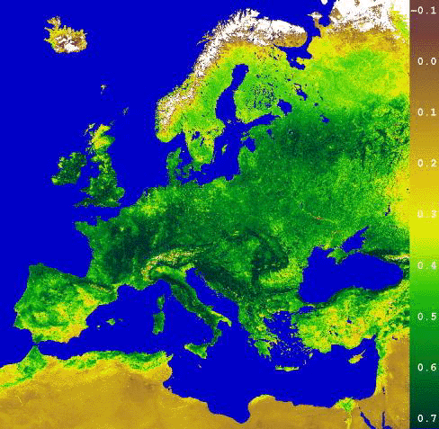
Here is an example of NDVI over Europe. derived by German Remote Sensing Data Center.
| Non-desert vegetation | 0.01 - 0.75 |
| Lakes, rivers, and ocean | negative values |
| Sparse desert vegetation | 0-0.01 |
| Clouds | 0-0.075 |
The NDVI is typically derived from observations from the Advanced Very High Resolution Radiometer (AVHRR), which makes observations a five wavelengths (early versions has only four observations). The AVHRR makes observations in the visible, near-infrared, and thermal infrared portions of the electromagnetic spectrum. This sensor is carried on NOAA's Polar Orbiting Environmental Satellites (POES), beginning with TIROS-N in 1978.